Thank you for supporting this site ❤️
Make a donation
Make a donation
Gear up for your next adventure:
As an Amazon Associate, this site earns from qualifying purchases at no extra cost to you.
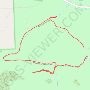
Potawatomi Trail
Pinckney State Recreation Area
- Distance: 2.8 Km
- Elevation gain: 13 m
- Maximum elevation: 290 m
- Elevation loss: 13 m
- Minimum elevation: 280 m
- Moving time: 18 m 21 s
- Moving speed: 9.0 Km/h
- Maximum speed: 28.1 Km/h
- Total time: 20 m 7 s
- Global speed: 8.2 Km/h
Interactive trail map
Thank you for supporting this site ❤️
Make a donation
Make a donation
Gear up for your next adventure:
As an Amazon Associate, this site earns from qualifying purchases at no extra cost to you.
Trail profile
- Distance: 2.8 Km
- Elevation gain: 13 m
- Maximum elevation: 290 m
- Elevation loss: 13 m
- Minimum elevation: 280 m
- Moving time: 18 m 21 s
- Moving speed: 9.0 Km/h
- Maximum speed: 28.1 Km/h
- Total time: 20 m 7 s
- Global speed: 8.2 Km/h
Thank you for supporting this site ❤️
Make a donation
Make a donation
Gear up for your next adventure:
As an Amazon Associate, this site earns from qualifying purchases at no extra cost to you.
About this trail
Name: Potawatomi Trail trail, distance, elevation, map, profile, GPS track
Coordinates: 42.42905 -84.01514 42.43404 -84.00537
Thank you for supporting this site ❤️
Make a donation
Make a donation
Gear up for your next adventure:
As an Amazon Associate, this site earns from qualifying purchases at no extra cost to you.