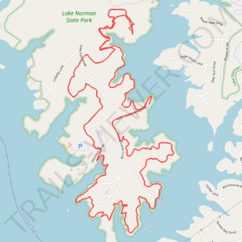
Lake Shore Loop Trail in Lake Norman State Park
- Distance: 12.4 Km
- Elevation gain: 209 m
- Maximum elevation: 264 m
- Elevation loss: 212 m
- Minimum elevation: 233 m
- Moving time: 1 h 32 m
- Moving speed: 8.0 Km/h
- Maximum speed: 14.7 Km/h
- Total time: 1 h 33 m
- Global speed: 7.9 Km/h
Interactive trail map
Trail profile
- Distance: 12.4 Km
- Elevation gain: 209 m
- Maximum elevation: 264 m
- Elevation loss: 212 m
- Minimum elevation: 233 m
- Moving time: 1 h 32 m
- Moving speed: 8.0 Km/h
- Maximum speed: 14.7 Km/h
- Total time: 1 h 33 m
- Global speed: 7.9 Km/h
About this trail
Name: Lake Shore Loop Trail in Lake Norman State Park trail, distance, elevation, map, profile, GPS track
Start: 199, Boat Launch Drive, Iredell County, North Carolina, 28677, United States (35.65329 -80.93905)
End: Iredell County, North Carolina, United States (35.65355 -80.93865)
Coordinates: 35.64178 -80.94776 35.66222 -80.93591
Other hiking, mountain biking, running and outdoor activity trails
Click on a trail to view its statistics, map and profile.
Lake Norman State Park Hike
United States > North Carolina > Iredell County
Distance: 5.7 Km • Elevation gain: 67 m • Maximum elevation: 256 m
Lake Shore Loop Trail
United States > North Carolina > Iredell County
Distance: 10.0 Km • Elevation gain: 159 m • Maximum elevation: 264 m
Lake Shore Loop Trail
United States > North Carolina > Iredell County
Distance: 8.9 Km • Elevation gain: 136 m • Maximum elevation: 266 m