Mount Mansfield Loop via Maple Ridge Trail, Long Trail and Sunset Ridge Trail
The Mount Mansfield Loop provides a challenging but rewarding hike to the highest peak in Vermont. As you climb, the varied terrain offers rocky paths, steep ascents, and exposed ridgelines, culminating in breathtaking panoramic views of the Champlain Valley, the Adirondacks, and the Green Mountains. The route’s rugged sections, particularly along Maple Ridge, involve technical scrambling and a thrilling rock gap crossing, making this loop best suited for experienced hikers comfortable with heights and rocky terrain. #Hiking #Loop #Mountain #Rock #Forest #Nature
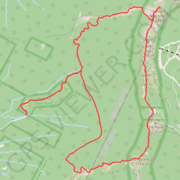
- Distance: 13.2 Km
- Elevation gain: 884 m
- Maximum elevation: 1,332 m
- Elevation loss: 883 m
- Minimum elevation: 532 m
- Moving time: 3 h 6 m
- Moving speed: 4.2 Km/h
- Maximum speed: 9.1 Km/h
- Total time: 3 h 33 m
- Global speed: 3.7 Km/h
Interactive trail map
Trail profile
- Distance: 13.2 Km
- Elevation gain: 884 m
- Maximum elevation: 1,332 m
- Elevation loss: 883 m
- Minimum elevation: 532 m
- Moving time: 3 h 6 m
- Moving speed: 4.2 Km/h
- Maximum speed: 9.1 Km/h
- Total time: 3 h 33 m
- Global speed: 3.7 Km/h
About this trail
Name: Mount Mansfield Loop via Maple Ridge Trail, Long Trail and Sunset Ridge Trail trail, distance, elevation, map, profile, GPS track
Coordinates: 44.51841 -72.84409 44.54398 -72.81431
Other hiking, mountain biking, running and outdoor activity trails
Click on a trail to view its statistics, map and profile.
The Chin of Mount Mansfield via Sunset Ridge Trail in Underhill State Park
United States > Vermont > Chittenden County > Underhill
The Sunset Ridge Trail to the summit of Mount Mansfield provides a challenging and rewarding hiking experience, offering expansive views of Vermont’s landscape. As you ascend through dense forests and rocky stretches, the trail opens up to panoramic vistas, where you can catch sight of distant valleys and…
Distance: 9.6 Km • Elevation gain: 801 m • Maximum elevation: 1,332 m