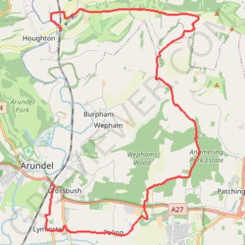
Walk Amberley to Arundel via Amberley Mount, Wepham Down, Black Ditch, Lynminster
Amberley, Arundel, Amberley Mount, Wepham Down, Black Ditch, Lynminster
- Distance: 23.2 Km
- Elevation gain: 314 m
- Maximum elevation: 194 m
- Elevation loss: 320 m
- Minimum elevation: -2 m
- Moving time: 5 h 58 m
- Moving speed: 3.9 Km/h
- Maximum speed: 7.9 Km/h
- Total time: 7 h 18 m
- Global speed: 3.2 Km/h
Interactive trail map
Trail profile
- Distance: 23.2 Km
- Elevation gain: 314 m
- Maximum elevation: 194 m
- Elevation loss: 320 m
- Minimum elevation: -2 m
- Moving time: 5 h 58 m
- Moving speed: 3.9 Km/h
- Maximum speed: 7.9 Km/h
- Total time: 7 h 18 m
- Global speed: 3.2 Km/h
About this trail
Name: Walk Amberley to Arundel via Amberley Mount, Wepham Down, Black Ditch, Lynminster trail, distance, elevation, map, profile, GPS track
Coordinates: 50.83189 -0.54941 50.90335 -0.47217