
Great Divide Trail Dutch Creek Tornado Pass to Cache Creek
- Distance: 20.6 Km
- Elevation gain: 897 m
- Maximum elevation: 2,475 m
- Elevation loss: 1,285 m
- Minimum elevation: 1,742 m
- Moving time: 6 h 48 m
- Moving speed: 3.0 Km/h
- Maximum speed: 3.7 Km/h
- Total time: 6 h 48 m
- Global speed: 3.0 Km/h
Interactive trail map
Trail profile
- Distance: 20.6 Km
- Elevation gain: 897 m
- Maximum elevation: 2,475 m
- Elevation loss: 1,285 m
- Minimum elevation: 1,742 m
- Moving time: 6 h 48 m
- Moving speed: 3.0 Km/h
- Maximum speed: 3.7 Km/h
- Total time: 6 h 48 m
- Global speed: 3.0 Km/h
About this trail
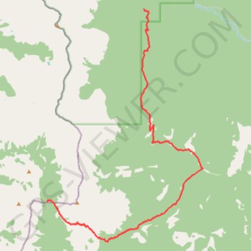
Name: Great Divide Trail Dutch Creek Tornado Pass to Cache Creek trail, distance, elevation, map, profile, GPS track
End: Great Divide Trail, Municipal District of Ranchland No. 66, Alberta, Canada (50.04212 -114.61421)
Coordinates: 49.95170 -114.67261 50.04212 -114.57818
Other hiking, mountain biking, running and outdoor activity trails
Click on a trail to view its statistics, map and profile.
Tornado Mountain and "Whirlwind Tower"
Canada > Alberta > Municipal District of Ranchland No. 66
Distance: 35.3 Km • Elevation gain: 2,073 m • Maximum elevation: 3,057 m