Devil's Chair
Hike to Devil's Chair via Devil's Chair Trail in Angeles National Forest. #Hiking #Mountain #Nature #Forest #Angeles
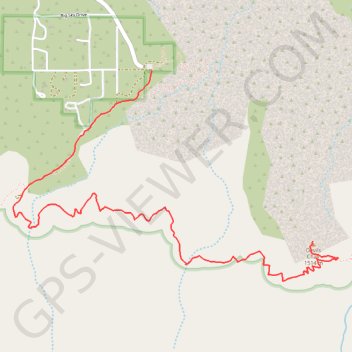
- Distance: 6.0 Km
- Elevation gain: 394 m
- Maximum elevation: 1,631 m
- Elevation loss: 367 m
- Minimum elevation: 1,456 m
- Moving time: 35 m 37 s
- Moving speed: 10.1 Km/h
- Maximum speed: 11.8 Km/h
- Total time: 35 m 37 s
- Global speed: 10.1 Km/h
Interactive trail map
Trail profile
- Distance: 6.0 Km
- Elevation gain: 394 m
- Maximum elevation: 1,631 m
- Elevation loss: 367 m
- Minimum elevation: 1,456 m
- Moving time: 35 m 37 s
- Moving speed: 10.1 Km/h
- Maximum speed: 11.8 Km/h
- Total time: 35 m 37 s
- Global speed: 10.1 Km/h
About this trail
Name: Devil's Chair trail, distance, elevation, map, profile, GPS track
Start: Devil's Chair Trail, Los Angeles County, California, United States (34.41366 -117.85855)
End: Devil's Chair Trail, Los Angeles County, California, United States (34.40239 -117.84567)
Coordinates: 34.39978 -117.86963 34.41366 -117.84360