Thank you for supporting this site ❤️
Make a donation
Make a donation
Gear up for your next adventure:
As an Amazon Associate, this site earns from qualifying purchases at no extra cost to you.
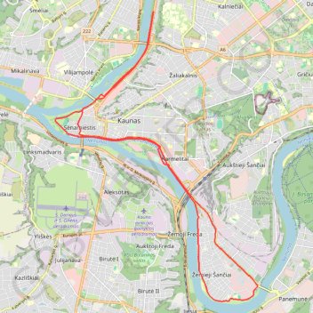
Trails.lt route
name=trails.lt route
- Distance: 21.2 Km
- Elevation gain: 129 m
- Maximum elevation: 36 m
- Elevation loss: 129 m
- Minimum elevation: 19 m
Interactive trail map
Thank you for supporting this site ❤️
Make a donation
Make a donation
Gear up for your next adventure:
As an Amazon Associate, this site earns from qualifying purchases at no extra cost to you.
Trail profile
- Distance: 21.2 Km
- Elevation gain: 129 m
- Maximum elevation: 36 m
- Elevation loss: 129 m
- Minimum elevation: 19 m
Thank you for supporting this site ❤️
Make a donation
Make a donation
Gear up for your next adventure:
As an Amazon Associate, this site earns from qualifying purchases at no extra cost to you.
About this trail
Name: Trails.lt route trail, distance, elevation, map, profile, GPS track
Coordinates: 54.86051 23.87786 54.92080 23.95118
Thank you for supporting this site ❤️
Make a donation
Make a donation
Gear up for your next adventure:
As an Amazon Associate, this site earns from qualifying purchases at no extra cost to you.