Seven Sacred Pools via Soldier Pass Trail in Coconino National Forest
The Soldier Pass Trail to the Seven Sacred Pools in Sedona offers a moderate hike through breathtaking red rock landscapes. Starting near Devil’s Kitchen, a dramatic sinkhole, the trail meanders past vibrant desert vegetation and sandstone formations, leading to the pools—small, naturally carved basins often holding water. With striking views of buttes and mesas along the way, this hike combines geological intrigue with serene vistas, making it a favorite for both nature lovers and photographers. #Hiking #Forest #Nature
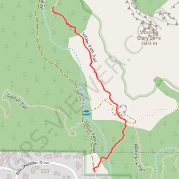
- Distance: 1.9 Km
- Elevation gain: 50 m
- Maximum elevation: 1,384 m
- Elevation loss: 50 m
- Minimum elevation: 1,356 m
Interactive trail map
Trail profile
- Distance: 1.9 Km
- Elevation gain: 50 m
- Maximum elevation: 1,384 m
- Elevation loss: 50 m
- Minimum elevation: 1,356 m
About this trail
Name: Seven Sacred Pools via Soldier Pass Trail in Coconino National Forest trail, distance, elevation, map, profile, GPS track
Start: Soldier Pass Trail, Sedona, Yavapai County, Arizona, 86336, United States (34.88418 -111.78379)
Coordinates: 34.88418 -111.78572 34.89044 -111.78233
Other hiking, mountain biking, running and outdoor activity trails
Click on a trail to view its statistics, map and profile.
Seven Sacred Pools and Soldiers Pass Cave via Soldiers Pass Trail in Coconino National Forest
United States > Arizona > Yavapai County > Sedona
The Soldiers Pass Trail offers a nice blend of moderate hiking with some stunning views along the way. As you approach the end, the sharp incline adds a bit of challenge, but it’s definitely rewarding to reach the beautiful cave. The shaded spots throughout the trail make it a pleasant escape, keeping the…
Distance: 5.7 Km • Elevation gain: 191 m • Maximum elevation: 1,505 m
Cibola Pass, Soldier Pass and Brins Mesa loop trails via Seven Sacred Pools and Soldier Pass Cave
United States > Arizona > Coconino County > Sedona
This loop hike around Brins Butte and Cibola Mitten is a fantastic way to immerse yourself in the stunning landscapes of Sedona. As you hike, you'll be treated to incredible views of the red rock formations and plenty of interesting geological features, like the Seven Sacred Pools and Soldier Pass Cave.…
Distance: 9.2 Km • Elevation gain: 347 m • Maximum elevation: 1,554 m