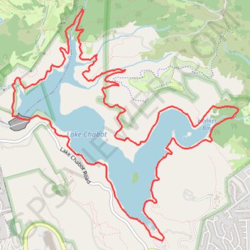
Lake Chabot Loop Trail in Lake Chabot Regional Park
The Lake Chabot Loop via West Shore Trail, Chabot Dam, Bass Cove Trail, Columbine Trail, Honker Bay Trail and East Shore Trail offers a scenic and varied hiking experience, weaving through shaded forests, sunny open trails, and peaceful lakeside paths. Hikers can enjoy sweeping views of Lake Chabot from elevated points, while sections like the Columbine Trail provide quiet, tree-covered pathways. The route features both wide, paved trails and narrower, more rugged segments, creating a dynamic experience that shifts from serene waterfront strolls to hillier, forested climbs. #Hiking #Loop #Lake #Forest #Nature
- Distance: 14.2 Km
- Elevation gain: 464 m
- Maximum elevation: 178 m
- Elevation loss: 464 m
- Minimum elevation: 67 m
- Moving time: 1 h 15 m
- Moving speed: 11.3 Km/h
- Maximum speed: 18.5 Km/h
- Total time: 1 h 15 m
- Global speed: 11.3 Km/h
Interactive trail map
Trail profile
- Distance: 14.2 Km
- Elevation gain: 464 m
- Maximum elevation: 178 m
- Elevation loss: 464 m
- Minimum elevation: 67 m
- Moving time: 1 h 15 m
- Moving speed: 11.3 Km/h
- Maximum speed: 18.5 Km/h
- Total time: 1 h 15 m
- Global speed: 11.3 Km/h
About this trail
Name: Lake Chabot Loop Trail in Lake Chabot Regional Park trail, distance, elevation, map, profile, GPS track
Coordinates: 37.71600 -122.12370 37.74176 -122.09183
Other hiking, mountain biking, running and outdoor activity trails
Click on a trail to view its statistics, map and profile.
Walking around Lake Chabot
United States > California > Alameda County > Castro Valley
Distance: 14.5 Km • Elevation gain: 520 m • Maximum elevation: 178 m