Tallarook - Granite
Great Victorian Rail Trail. #Bike
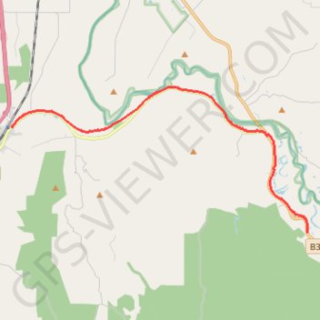
- Distance: 14.8 Km
- Elevation gain: 138 m
- Maximum elevation: 185 m
- Elevation loss: 144 m
- Minimum elevation: 148 m
Interactive trail map
Trail profile
- Distance: 14.8 Km
- Elevation gain: 138 m
- Maximum elevation: 185 m
- Elevation loss: 144 m
- Minimum elevation: 148 m
About this trail
Name: Tallarook - Granite trail, distance, elevation, map, profile, GPS track
Start: Upper Goulburn Road, Tallarook, Shire of Mitchell, Victoria, 3659, Australia (-37.09250 145.10462)
Coordinates: -37.12581 145.10462 -37.07971 145.22181
Topography: Victoria topographic map, elevation, terrain
Other hiking, mountain biking, running and outdoor activity trails
Click on a trail to view its statistics, map and profile.
Tallarook - Eildon - Hurstbridge
Australia > Victoria > Tallarook
#Bike
Distance: 278.8 Km • Elevation gain: 4,897 m • Maximum elevation: 868 m
Yea - Granite
Great Victorian Rail Trail. #Bike
Distance: 24.6 Km • Elevation gain: 257 m • Maximum elevation: 220 m