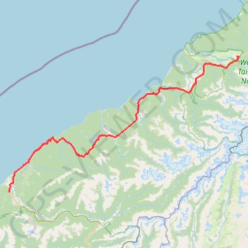
Import a GPX file

Haast - Fox Glacier

#Bike #Pacific

  • Distance: 121.7 Km
  • Elevation gain: 1,246 m
  • Maximum elevation: 193 m
  • Elevation loss: 1,102 m
  • Minimum elevation: 2 m

Interactive trail map

Trail profile

  • Distance: 121.7 Km
  • Elevation gain: 1,246 m
  • Maximum elevation: 193 m
  • Elevation loss: 1,102 m
  • Minimum elevation: 2 m

About this trail

Other hiking, mountain biking, running and outdoor activity trails

Click on a trail to view its statistics, map and profile.

Tour Te Waipounamu

New Zealand > Tasman > Tasman District > Port Pūponga

Bikepacking race through the South Island of New Zealand. #Bike #Race #Island #Sea #Pacific #Ocean #Nature #Mountain #Forest #Countryside

Distance: 1,321.0 Km • Elevation gain: 23,362 m • Maximum elevation: 1,946 m

Copland Track to Welcome Flat Hut

New Zealand > West Coast > Westland District

Distance: 17.5 Km • Elevation gain: 835 m • Maximum elevation: 481 m

Gear up for your next adventure:

👕UPF 50+ Sun Shirts - Essential protection against the harsh Australian sun during field work
📻Handheld UHF Radios - Critical communication for groups in the Australian outback
📡Portable Emergency Radios - Stay informed about weather warnings and bushfire alerts
🩹Blister Prevention Tape - Apply to friction points before they become painful sores
📕Hiking Guide Books - Guides for hiking trails

As an Amazon Associate, this site earns from qualifying purchases at no extra cost to you.