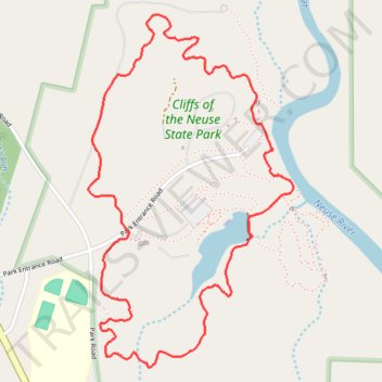
Cliffs of the Neuse State Park Loop via Lake Trail, Spanish Moss Trail and Long Leaf Trail
- Distance: 5.6 Km
- Elevation gain: 61 m
- Maximum elevation: 49 m
- Elevation loss: 62 m
- Minimum elevation: 22 m
- Moving time: 1 h 17 m
- Moving speed: 4.3 Km/h
- Maximum speed: 8.7 Km/h
- Total time: 1 h 18 m
- Global speed: 4.2 Km/h
Interactive trail map
Trail profile
- Distance: 5.6 Km
- Elevation gain: 61 m
- Maximum elevation: 49 m
- Elevation loss: 62 m
- Minimum elevation: 22 m
- Moving time: 1 h 17 m
- Moving speed: 4.3 Km/h
- Maximum speed: 8.7 Km/h
- Total time: 1 h 18 m
- Global speed: 4.2 Km/h
About this trail
Name: Cliffs of the Neuse State Park Loop via Lake Trail, Spanish Moss Trail and Long Leaf Trail trail, distance, elevation, map, profile, GPS track
Start: 247, Park Entrance Road, Wayne County, North Carolina, 28578, United States (35.23623 -77.89128)
End: Park Entrance Road, Wayne County, North Carolina, 28578, United States (35.23608 -77.89111)
Coordinates: 35.23043 -77.89325 35.24528 -77.88270
Other hiking, mountain biking, running and outdoor activity trails
Click on a trail to view its statistics, map and profile.
Cliffs of the Neuse River
United States > North Carolina > Wayne County
Distance: 1.6 Km • Elevation gain: 30 m • Maximum elevation: 47 m