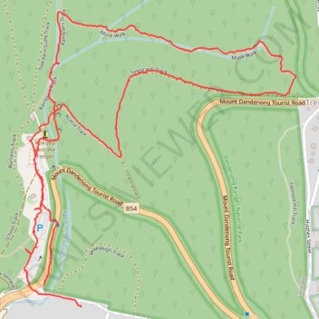
Musk loop
- Distance: 4.3 Km
- Elevation gain: 222 m
- Maximum elevation: 380 m
- Elevation loss: 219 m
- Minimum elevation: 161 m
- Moving time: 52 m 11 s
- Moving speed: 4.9 Km/h
- Maximum speed: 14.9 Km/h
- Total time: 1 h 5 m
- Global speed: 3.9 Km/h
Interactive trail map
Trail profile
- Distance: 4.3 Km
- Elevation gain: 222 m
- Maximum elevation: 380 m
- Elevation loss: 219 m
- Minimum elevation: 161 m
- Moving time: 52 m 11 s
- Moving speed: 4.9 Km/h
- Maximum speed: 14.9 Km/h
- Total time: 1 h 5 m
- Global speed: 3.9 Km/h
About this trail
Name: Musk loop trail, distance, elevation, map, profile, GPS track
Start: Tremont, Melbourne, Shire of Yarra Ranges, Victoria, 3785, Australia (-37.89185 145.31781)
Coordinates: -37.89250 145.31702 -37.88368 145.32734
Topography: Melbourne topographic map, elevation, terrain
Other hiking, mountain biking, running and outdoor activity trails
Click on a trail to view its statistics, map and profile.
Upwey, Tremont Hill, One Tree Hill and Sherbrooke Falls loop
Australia > Victoria > Melbourne
Distance: 16.4 Km • Elevation gain: 688 m • Maximum elevation: 525 m
Upper Ferntree Gully
Australia > Victoria > Melbourne
Upftg ride
Distance: 44.0 Km • Elevation gain: 1,583 m • Maximum elevation: 529 m
Dandenong Ranges National Park Ridgewalk
Australia > Victoria > Melbourne > Tremont
Distance: 22.1 Km • Elevation gain: 1,002 m • Maximum elevation: 591 m