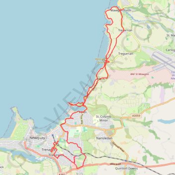
Newquay to Mawgan Porth
Interactive trail map
Trail profile
- Distance: 24.9 Km
- Elevation gain: 728 m
- Maximum elevation: 85 m
- Elevation loss: 722 m
- Minimum elevation: 0 m
About this trail
Name: Newquay to Mawgan Porth trail, distance, elevation, map, profile, GPS track
Coordinates: 50.40089 -5.07637 50.46628 -5.02967
Other hiking, mountain biking, running and outdoor activity trails
Click on a trail to view its statistics, map and profile.
Newquay to Penhale Sands
United Kingdom > England > Cornwall > Newquay
Distance: 28.9 Km • Elevation gain: 711 m • Maximum elevation: 88 m