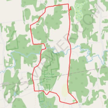
Carse Natural Area Loop
- Distance: 17.9 Km
- Elevation gain: 330 m
- Maximum elevation: 200 m
- Elevation loss: 325 m
- Minimum elevation: 92 m
- Moving time: 1 h 29 m
- Moving speed: 12.0 Km/h
- Maximum speed: 18.1 Km/h
- Total time: 1 h 30 m
- Global speed: 11.8 Km/h
Interactive trail map
Trail profile
- Distance: 17.9 Km
- Elevation gain: 330 m
- Maximum elevation: 200 m
- Elevation loss: 325 m
- Minimum elevation: 92 m
- Moving time: 1 h 29 m
- Moving speed: 12.0 Km/h
- Maximum speed: 18.1 Km/h
- Total time: 1 h 30 m
- Global speed: 11.8 Km/h
About this trail
Name: Carse Natural Area Loop trail, distance, elevation, map, profile, GPS track
Start: 174, Roscoe Road, Charlotte, Chittenden County, Vermont, 05445, United States (44.28952 -73.15058)
End: 115, Roscoe Road, Charlotte, Chittenden County, Vermont, 05445, United States (44.28996 -73.15095)
Coordinates: 44.25893 -73.16164 44.31272 -73.12624
Other hiking, mountain biking, running and outdoor activity trails
Click on a trail to view its statistics, map and profile.
Around lake Champlain with ferry between Essex NY/Charlotte VT
United States > Vermont > Chittenden County > South Burlington
Distance: 222.8 Km • Elevation gain: 1,742 m • Maximum elevation: 198 m