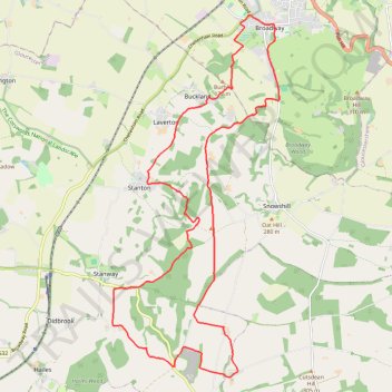
Broadway ➡️ Wood Stanway ➡️ Cutsdean ➡️ Broadway
- Distance: 24.4 Km
- Elevation gain: 605 m
- Maximum elevation: 304 m
- Elevation loss: 606 m
- Minimum elevation: 77 m
- Moving time: 2 h 44 m
- Moving speed: 8.9 Km/h
- Maximum speed: 18.8 Km/h
- Total time: 2 h 44 m
- Global speed: 8.9 Km/h
Interactive trail map
Trail profile
- Distance: 24.4 Km
- Elevation gain: 605 m
- Maximum elevation: 304 m
- Elevation loss: 606 m
- Minimum elevation: 77 m
- Moving time: 2 h 44 m
- Moving speed: 8.9 Km/h
- Maximum speed: 18.8 Km/h
- Total time: 2 h 44 m
- Global speed: 8.9 Km/h
About this trail
Name: Broadway ➡️ Wood Stanway ➡️ Cutsdean ➡️ Broadway trail, distance, elevation, map, profile, GPS track
Coordinates: 51.97011 -1.90960 52.03784 -1.85897
Other hiking, mountain biking, running and outdoor activity trails
Click on a trail to view its statistics, map and profile.
Blockley 🔁 Snowshill
United Kingdom > England > Gloucestershire > Cotswold District > Blockley
Blockley-Snowshill loop trailrun
Distance: 25.0 Km • Elevation gain: 500 m • Maximum elevation: 317 m
Broadway ↗️ Snowshill ↘️ Stanton ➡️ Buckland
United Kingdom > England > Worcestershire > Wychavon > Broadway
Distance: 22.6 Km • Elevation gain: 706 m • Maximum elevation: 322 m
Hayles Loop Walk
United Kingdom > England > Gloucestershire > Tewkesbury > Hailes
Distance: 8.3 Km • Elevation gain: 199 m • Maximum elevation: 278 m