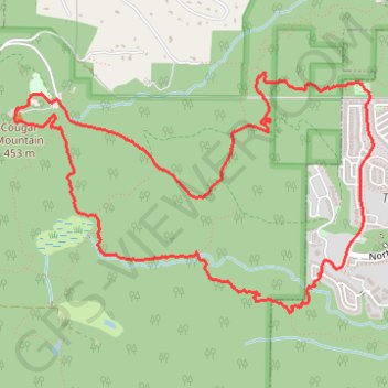
Cougar Mountain Loop
Loop hike to Cougar Mountain via Talus Bridge Trail, Bear Ridge Trail, West Tibbetts Creek Trail, Tibbetts Marsh Trail, Lost Beagle Trail, Southeast Cougar Mountain Drive, Shangri La Trail, No Name Trail, Surprise Creek Trail, Precipice Top Trail, Military Ridge Trail, Trearis Trail and Shangri-La Way Northwest in the Cougar Mountain Regional Wildland Park. #Hiking #Loop #Mountain #Nature #Forest #Park
- Distance: 8.5 Km
- Elevation gain: 358 m
- Maximum elevation: 454 m
- Elevation loss: 356 m
- Minimum elevation: 116 m
- Moving time: 2 h 52 m
- Moving speed: 2.9 Km/h
- Maximum speed: 11.6 Km/h
- Total time: 3 h 55 m
- Global speed: 2.2 Km/h
Interactive trail map
Trail profile
- Distance: 8.5 Km
- Elevation gain: 358 m
- Maximum elevation: 454 m
- Elevation loss: 356 m
- Minimum elevation: 116 m
- Moving time: 2 h 52 m
- Moving speed: 2.9 Km/h
- Maximum speed: 11.6 Km/h
- Total time: 3 h 55 m
- Global speed: 2.2 Km/h
About this trail
Name: Cougar Mountain Loop trail, distance, elevation, map, profile, GPS track
Coordinates: 47.52949 -122.09964 47.54246 -122.07108
Other hiking, mountain biking, running and outdoor activity trails
Click on a trail to view its statistics, map and profile.
Northern part of the Pacific Crest Trail (PCT)
United States > Oregon > Klamath County
Hike on the Pacific Crest National Scenic Trail from Crater Lake to Canada Border through Oregon and Washington along the Sierra Nevada and Cascade mountain ranges. #Hiking #Mountain #SierraNevada #Cascade #Nature #Forest #Park #PCT
Distance: 1,198.3 Km • Elevation gain: 44,308 m • Maximum elevation: 2,307 m
Cougar Mountain Loop Hike
United States > Washington > King County > Renton > Coal Creek
Distance: 11.2 Km • Elevation gain: 376 m • Maximum elevation: 455 m