Thank you for supporting this site ❤️
Make a donation
Make a donation
Gear up for your next adventure:
As an Amazon Associate, this site earns from qualifying purchases at no extra cost to you.
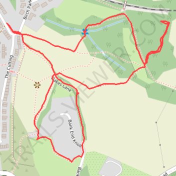
Brockholes woods explore
- Distance: 2.1 Km
- Elevation gain: 78 m
- Maximum elevation: 200 m
- Elevation loss: 78 m
- Minimum elevation: 145 m
- Moving time: 1 h 2 m
- Moving speed: 2.1 Km/h
- Maximum speed: 3.6 Km/h
- Total time: 1 h 33 m
- Global speed: 1.4 Km/h
Interactive trail map
Thank you for supporting this site ❤️
Make a donation
Make a donation
Gear up for your next adventure:
As an Amazon Associate, this site earns from qualifying purchases at no extra cost to you.
Trail profile
- Distance: 2.1 Km
- Elevation gain: 78 m
- Maximum elevation: 200 m
- Elevation loss: 78 m
- Minimum elevation: 145 m
- Moving time: 1 h 2 m
- Moving speed: 2.1 Km/h
- Maximum speed: 3.6 Km/h
- Total time: 1 h 33 m
- Global speed: 1.4 Km/h
Thank you for supporting this site ❤️
Make a donation
Make a donation
Gear up for your next adventure:
As an Amazon Associate, this site earns from qualifying purchases at no extra cost to you.
About this trail
Name: Brockholes woods explore trail, distance, elevation, map, profile, GPS track
Coordinates: 53.58959 -1.76725 53.59345 -1.76011
Thank you for supporting this site ❤️
Make a donation
Make a donation
Gear up for your next adventure:
As an Amazon Associate, this site earns from qualifying purchases at no extra cost to you.
Other hiking, mountain biking, running and outdoor activity trails
Click on a trail to view its statistics, map and profile.
Brockholes and Thurstonland Loop
United Kingdom > England > Kirklees > Brockholes > Upper Hagg
Distance: 4.1 Km • Elevation gain: 144 m • Maximum elevation: 262 m