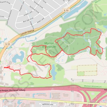
Arboretum has a new connector path
First light after main shingles sizzles ♨️. Super day!
- Distance: 6.6 Km
- Elevation gain: 49 m
- Maximum elevation: 232 m
- Elevation loss: 53 m
- Minimum elevation: 208 m
- Moving time: 1 h 24 m
- Moving speed: 4.7 Km/h
- Maximum speed: 12.3 Km/h
- Total time: 1 h 27 m
- Global speed: 4.5 Km/h
Interactive trail map
Trail profile
- Distance: 6.6 Km
- Elevation gain: 49 m
- Maximum elevation: 232 m
- Elevation loss: 53 m
- Minimum elevation: 208 m
- Moving time: 1 h 24 m
- Moving speed: 4.7 Km/h
- Maximum speed: 12.3 Km/h
- Total time: 1 h 27 m
- Global speed: 4.5 Km/h
About this trail
Name: Arboretum has a new connector path trail, distance, elevation, map, profile, GPS track
Coordinates: 41.81187 -88.07228 41.82000 -88.05065