Natural Bridge and Battleship Rock Trail in Natural Bridge State Resort Park
Natural Bridge and Battleship Rock Trail offers hikers a fantastic experience of Kentucky's natural beauty. Along the route, you'll encounter the iconic Natural Bridge, a large sandstone arch with stunning views of the surrounding forest and cliffs. The trail continues to Battleship Rock, where you can appreciate unique rock formations and sweeping vistas over the Red River Gorge area, making it a perfect spot for nature photography. This relatively moderate trail, shaded by dense trees, provides a peaceful escape with the occasional challenge of uneven terrain, but it rewards visitors with unforgettable scenery and geological wonders. #Hiking #Arch #Rock #Forest #Nature
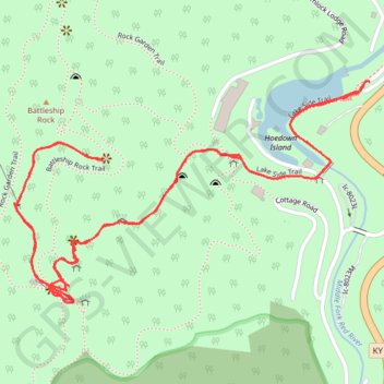
- Distance: 4.2 Km
- Elevation gain: 191 m
- Maximum elevation: 383 m
- Elevation loss: 190 m
- Minimum elevation: 235 m
- Moving time: 1 h 8 m
- Moving speed: 3.7 Km/h
- Maximum speed: 9.5 Km/h
- Total time: 1 h 23 m
- Global speed: 3.0 Km/h
Interactive trail map
Trail profile
- Distance: 4.2 Km
- Elevation gain: 191 m
- Maximum elevation: 383 m
- Elevation loss: 190 m
- Minimum elevation: 235 m
- Moving time: 1 h 8 m
- Moving speed: 3.7 Km/h
- Maximum speed: 9.5 Km/h
- Total time: 1 h 23 m
- Global speed: 3.0 Km/h
About this trail
Name: Natural Bridge and Battleship Rock Trail in Natural Bridge State Resort Park trail, distance, elevation, map, profile, GPS track
Start: Lakeside Trail Loop, Powell County, Kentucky, 40376, United States (37.77765 -83.67672)
End: Lakeside Trail Loop, Powell County, Kentucky, 40376, United States (37.77764 -83.67670)
Coordinates: 37.77283 -83.68647 37.77765 -83.67670
Other hiking, mountain biking, running and outdoor activity trails
Click on a trail to view its statistics, map and profile.
Natural Bridge Trail, Laurel Bridge Trail and Battleship Rock Trail Loop
United States > Kentucky > Powell County
This loop in Kentucky’s Natural Bridge State Resort Park takes hikers through a vibrant forest landscape, leading to sweeping cliffside views and impressive sandstone formations. Notable highlights include the breathtaking view from atop the Natural Bridge and the thrilling descent through narrow rock…
Distance: 3.2 Km • Elevation gain: 182 m • Maximum elevation: 393 m