Thank you for supporting this site ❤️
Make a donation
Make a donation
Gear up for your next adventure:
As an Amazon Associate, this site earns from qualifying purchases at no extra cost to you.
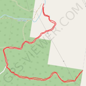
Orara West State Forest
Morning Run
- Distance: 8.8 Km
- Elevation gain: 506 m
- Maximum elevation: 368 m
- Elevation loss: 512 m
- Minimum elevation: 105 m
- Moving time: 1 h 23 m
- Moving speed: 6.3 Km/h
- Maximum speed: 17.0 Km/h
- Total time: 1 h 27 m
- Global speed: 6.0 Km/h
Interactive trail map
Thank you for supporting this site ❤️
Make a donation
Make a donation
Gear up for your next adventure:
As an Amazon Associate, this site earns from qualifying purchases at no extra cost to you.
Trail profile
- Distance: 8.8 Km
- Elevation gain: 506 m
- Maximum elevation: 368 m
- Elevation loss: 512 m
- Minimum elevation: 105 m
- Moving time: 1 h 23 m
- Moving speed: 6.3 Km/h
- Maximum speed: 17.0 Km/h
- Total time: 1 h 27 m
- Global speed: 6.0 Km/h
Thank you for supporting this site ❤️
Make a donation
Make a donation
Gear up for your next adventure:
As an Amazon Associate, this site earns from qualifying purchases at no extra cost to you.
About this trail
Name: Orara West State Forest trail, distance, elevation, map, profile, GPS track
Coordinates: -30.24155 152.99579 -30.22669 153.01322
Topography: New South Wales topographic map, elevation, terrain
Thank you for supporting this site ❤️
Make a donation
Make a donation
Gear up for your next adventure:
As an Amazon Associate, this site earns from qualifying purchases at no extra cost to you.
Other hiking, mountain biking, running and outdoor activity trails
Click on a trail to view its statistics, map and profile.
Star Creek / Comlaroi Road explore
Australia > New South Wales > Coramba
Distance: 5.0 Km • Elevation gain: 227 m • Maximum elevation: 308 m