Import a GPX file

Hiking trails in the Zoar Valley Unique Area

  • Distance: 3.7 Km
  • Elevation gain: 103 m
  • Maximum elevation: 431 m
  • Elevation loss: 67 m
  • Minimum elevation: 385 m
  • Moving time: 1 h 5 m
  • Moving speed: 3.4 Km/h
  • Maximum speed: 15.3 Km/h
  • Total time: 1 h 19 m
  • Global speed: 2.8 Km/h

Interactive trail map

Trail profile

  • Distance: 3.7 Km
  • Elevation gain: 103 m
  • Maximum elevation: 431 m
  • Elevation loss: 67 m
  • Minimum elevation: 385 m
  • Moving time: 1 h 5 m
  • Moving speed: 3.4 Km/h
  • Maximum speed: 15.3 Km/h
  • Total time: 1 h 19 m
  • Global speed: 2.8 Km/h

About this trail
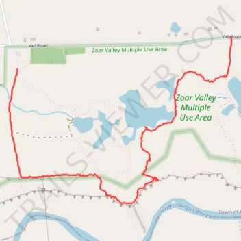
Name: Hiking trails in the Zoar Valley Unique Area trail, distance, elevation, map, profile, GPS track

Start: Holcomb Pond Trail, Town of Collins, Erie County, New York, 14035, United States (42.45010 -78.87937)

End: Zoar Holcomb Pond parking lot, Vail Road, Town of Collins, Erie County, New York, 14070, United States (42.45190 -78.86281)

Coordinates: 42.44241 -78.87997 42.45193 -78.86264

Gear up for your next adventure:

🥾Heavy Duty Hiking Boots - Ankle-supporting boots for carrying heavy packs on steep contours
🧭Military Style Lensatic Compass - Durable sighting compasses for advanced land navigation and surveying
🔑Heavy Duty Carabiners - Secure gear to the outside of your pack for easy access
🆘Personal Locator Beacons (PLB) - Satellite emergency beacons for life-saving help in areas with no mobile coverage
🧊Insulated Stainless Steel Flasks - Keep water cold for 24 hours in the heat or coffee hot in the cold

As an Amazon Associate, this site earns from qualifying purchases at no extra cost to you.