Thank you for supporting this site ❤️
Make a donation
Make a donation
Gear up for your next adventure:
As an Amazon Associate, this site earns from qualifying purchases at no extra cost to you.
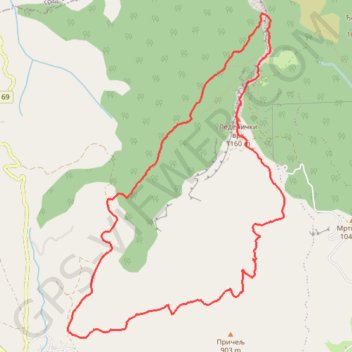
2021-02-21 13:09:02
- Distance: 10.7 Km
- Elevation gain: 658 m
- Maximum elevation: 1,147 m
- Elevation loss: 659 m
- Minimum elevation: 568 m
- Moving time: 3 h 29 m
- Moving speed: 3.1 Km/h
- Maximum speed: 7.7 Km/h
- Total time: 5 h 47 s
- Global speed: 2.1 Km/h
Interactive trail map
Thank you for supporting this site ❤️
Make a donation
Make a donation
Gear up for your next adventure:
As an Amazon Associate, this site earns from qualifying purchases at no extra cost to you.
Trail profile
- Distance: 10.7 Km
- Elevation gain: 658 m
- Maximum elevation: 1,147 m
- Elevation loss: 659 m
- Minimum elevation: 568 m
- Moving time: 3 h 29 m
- Moving speed: 3.1 Km/h
- Maximum speed: 7.7 Km/h
- Total time: 5 h 47 s
- Global speed: 2.1 Km/h
Thank you for supporting this site ❤️
Make a donation
Make a donation
Gear up for your next adventure:
As an Amazon Associate, this site earns from qualifying purchases at no extra cost to you.
About this trail
Name: 2021-02-21 13:09:02 trail, distance, elevation, map, profile, GPS track
Coordinates: 43.68321 22.13126 43.71196 22.15769
Thank you for supporting this site ❤️
Make a donation
Make a donation
Gear up for your next adventure:
As an Amazon Associate, this site earns from qualifying purchases at no extra cost to you.