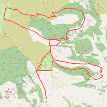
Sneck Yate loop
Hambleton Mountain Biking in North York Moors National Park
- Distance: 24.3 Km
- Elevation gain: 590 m
- Maximum elevation: 365 m
- Elevation loss: 591 m
- Minimum elevation: 144 m
- Moving time: 3 h 1 m
- Moving speed: 8.1 Km/h
- Maximum speed: 37.9 Km/h
- Total time: 3 h 32 m
- Global speed: 6.9 Km/h
Interactive trail map
Trail profile
- Distance: 24.3 Km
- Elevation gain: 590 m
- Maximum elevation: 365 m
- Elevation loss: 591 m
- Minimum elevation: 144 m
- Moving time: 3 h 1 m
- Moving speed: 8.1 Km/h
- Maximum speed: 37.9 Km/h
- Total time: 3 h 32 m
- Global speed: 6.9 Km/h
About this trail
Name: Sneck Yate loop trail, distance, elevation, map, profile, GPS track
Coordinates: 54.28240 -1.24905 54.32049 -1.17820