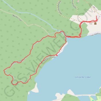
Red Spruce Trail
- Distance: 2.8 Km
- Elevation gain: 50 m
- Maximum elevation: 193 m
- Elevation loss: 50 m
- Minimum elevation: 153 m
- Moving time: 49 m 51 s
- Moving speed: 3.4 Km/h
- Maximum speed: 5.4 Km/h
- Total time: 1 h 2 m
- Global speed: 2.7 Km/h
Interactive trail map
Trail profile
- Distance: 2.8 Km
- Elevation gain: 50 m
- Maximum elevation: 193 m
- Elevation loss: 50 m
- Minimum elevation: 153 m
- Moving time: 49 m 51 s
- Moving speed: 3.4 Km/h
- Maximum speed: 5.4 Km/h
- Total time: 1 h 2 m
- Global speed: 2.7 Km/h
About this trail
Name: Red Spruce Trail trail, distance, elevation, map, profile, GPS track
Coordinates: 44.89643 -63.85528 44.90217 -63.84431
Other hiking, mountain biking, running and outdoor activity trails
Click on a trail to view its statistics, map and profile.
Mount Uniack Estate - Wilderness Loop
Canada > Nova Scotia > Hants County > Mount Uniacke
Distance: 7.2 Km • Elevation gain: 89 m • Maximum elevation: 191 m