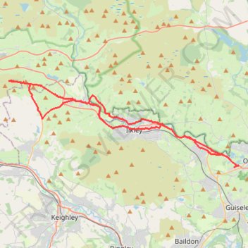
Otley - Draughton/Skipton Moor and return
- Distance: 41.3 Km
- Elevation gain: 456 m
- Maximum elevation: 318 m
- Elevation loss: 447 m
- Minimum elevation: 55 m
- Moving time: 3 h 6 m
- Moving speed: 13.3 Km/h
- Maximum speed: 38.6 Km/h
- Total time: 4 h 14 m
- Global speed: 9.7 Km/h
Interactive trail map
Trail profile
- Distance: 41.3 Km
- Elevation gain: 456 m
- Maximum elevation: 318 m
- Elevation loss: 447 m
- Minimum elevation: 55 m
- Moving time: 3 h 6 m
- Moving speed: 13.3 Km/h
- Maximum speed: 38.6 Km/h
- Total time: 4 h 14 m
- Global speed: 9.7 Km/h
About this trail
Name: Otley - Draughton/Skipton Moor and return trail, distance, elevation, map, profile, GPS track
Coordinates: 53.90126 -1.96374 53.95787 -1.70757
Other hiking, mountain biking, running and outdoor activity trails
Click on a trail to view its statistics, map and profile.
Otley - Eccup Reservoir - Harewood Bank - Otley (bicycle)
United Kingdom > England > Otley
Distance: 34.9 Km • Elevation gain: 377 m • Maximum elevation: 179 m
Otley - Eccup Reservoir - Harewood Bank - Otley (bicycle)
United Kingdom > England > Otley
Distance: 34.5 Km • Elevation gain: 364 m • Maximum elevation: 178 m
Otley Chevin
United Kingdom > England > Otley
Distance: 8.8 Km • Elevation gain: 238 m • Maximum elevation: 278 m
Otley - Farnley - Clifton - Otley (foot)
United Kingdom > England > North Yorkshire > Otley
Distance: 7.6 Km • Elevation gain: 144 m • Maximum elevation: 209 m
Burley Woodhead walk (foot)
United Kingdom > England > Bradford > Menston
Menston - Burley Woodhead - Burley - Menston
Distance: 12.1 Km • Elevation gain: 253 m • Maximum elevation: 299 m
Trails and canal from Silsden
United Kingdom > England > Bradford > Silsden
Distance: 5.0 Km • Elevation gain: 68 m • Maximum elevation: 157 m
White Wells Loop
United Kingdom > England > Bradford > Ilkley
Distance: 5.0 Km • Elevation gain: 230 m • Maximum elevation: 317 m