Make a donation
Gear up for your next adventure:
As an Amazon Associate, this site earns from qualifying purchases at no extra cost to you.
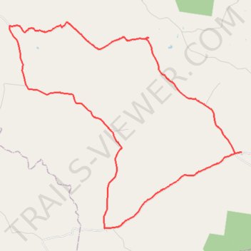
Manumbar and Elgin Vale
Barambah, Manumbar, Elgin Vale, Queensland
- Distance: 49.0 Km
- Elevation gain: 791 m
- Maximum elevation: 515 m
- Elevation loss: 791 m
- Minimum elevation: 340 m
Interactive trail map
Make a donation
Gear up for your next adventure:
As an Amazon Associate, this site earns from qualifying purchases at no extra cost to you.
Trail profile
- Distance: 49.0 Km
- Elevation gain: 791 m
- Maximum elevation: 515 m
- Elevation loss: 791 m
- Minimum elevation: 340 m
Make a donation
Gear up for your next adventure:
As an Amazon Associate, this site earns from qualifying purchases at no extra cost to you.
About this trail
Name: Manumbar and Elgin Vale trail, distance, elevation, map, profile, GPS track
Start: Elginvale Road, Barambah, Gympie Regional, Queensland, 4601, Australia (-26.32627 152.12897)
End: Elginvale Road, Barambah, Gympie Regional, Queensland, 4601, Australia (-26.32625 152.12898)
Coordinates: -26.44101 152.12871 -26.32432 152.27584
Topography: Queensland topographic map, elevation, terrain
Make a donation
Gear up for your next adventure:
As an Amazon Associate, this site earns from qualifying purchases at no extra cost to you.
Other hiking, mountain biking, running and outdoor activity trails
Click on a trail to view its statistics, map and profile.
Track Kilkivan towards Kandanga
Australia > Queensland > Kilkivan
Distance: 68.3 Km • Elevation gain: 1,770 m • Maximum elevation: 703 m
Johnstown to Elgin Vale loop
Distance: 36.4 Km • Elevation gain: 488 m • Maximum elevation: 516 m