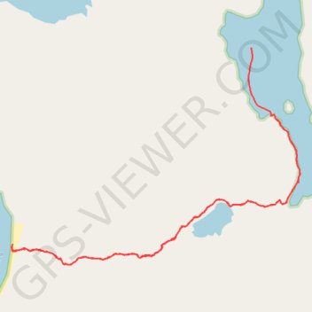
Sea Lion Cove Trailhead
Lunch Hike
- Distance: 9.5 Km
- Elevation gain: 298 m
- Maximum elevation: 106 m
- Elevation loss: 304 m
- Minimum elevation: 0 m
- Moving time: 3 h 5 m
- Moving speed: 3.1 Km/h
- Maximum speed: 8.0 Km/h
- Total time: 4 h 22 m
- Global speed: 2.2 Km/h
Interactive trail map
Trail profile
- Distance: 9.5 Km
- Elevation gain: 298 m
- Maximum elevation: 106 m
- Elevation loss: 304 m
- Minimum elevation: 0 m
- Moving time: 3 h 5 m
- Moving speed: 3.1 Km/h
- Maximum speed: 8.0 Km/h
- Total time: 4 h 22 m
- Global speed: 2.2 Km/h
About this trail
Name: Sea Lion Cove Trailhead trail, distance, elevation, map, profile, GPS track
Start: Sea Lion Cove Trail, Sitka, Alaska, United States (57.31376 -135.78541)
End: Sitka, Alaska, 99835, United States (57.31965 -135.78920)
Coordinates: 57.30155 -135.82617 57.31972 -135.78154