Thank you for supporting this site ❤️
Make a donation
Make a donation
Gear up for your next adventure:
As an Amazon Associate, this site earns from qualifying purchases at no extra cost to you.
Federation Trail - Surfers Paradise
Interactive trail map
Thank you for supporting this site ❤️
Make a donation
Make a donation
Gear up for your next adventure:
As an Amazon Associate, this site earns from qualifying purchases at no extra cost to you.
Trail profile
- Distance: 7.7 Km
- Elevation gain: 48 m
- Maximum elevation: 10 m
- Elevation loss: 46 m
- Minimum elevation: -1 m
Thank you for supporting this site ❤️
Make a donation
Make a donation
Gear up for your next adventure:
As an Amazon Associate, this site earns from qualifying purchases at no extra cost to you.
About this trail
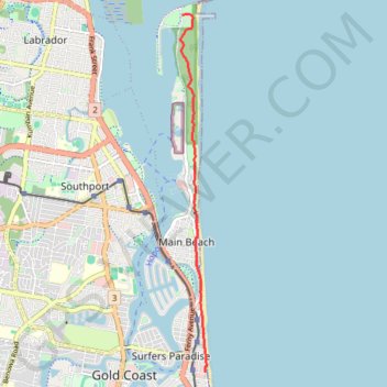
Name: Federation Trail - Surfers Paradise trail, distance, elevation, map, profile, GPS track
Start: Sea World Drive, Main Beach, Gold Coast City, Queensland, 4215, Australia (-27.93838 153.42641)
Coordinates: -28.00194 153.42592 -27.93832 153.43123
Topography: Gold Coast City topographic map, elevation, terrain
Thank you for supporting this site ❤️
Make a donation
Make a donation
Gear up for your next adventure:
As an Amazon Associate, this site earns from qualifying purchases at no extra cost to you.