Thank you for supporting this site ❤️
Make a donation
Make a donation
Gear up for your next adventure:
As an Amazon Associate, this site earns from qualifying purchases at no extra cost to you.
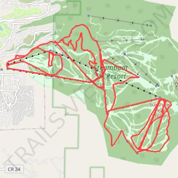
Steamboat Ski Resort
- Distance: 50.6 Km
- Elevation gain: 4,624 m
- Maximum elevation: 3,163 m
- Elevation loss: 4,622 m
- Minimum elevation: 2,106 m
Interactive trail map
Thank you for supporting this site ❤️
Make a donation
Make a donation
Gear up for your next adventure:
As an Amazon Associate, this site earns from qualifying purchases at no extra cost to you.
Trail profile
- Distance: 50.6 Km
- Elevation gain: 4,624 m
- Maximum elevation: 3,163 m
- Elevation loss: 4,622 m
- Minimum elevation: 2,106 m
Thank you for supporting this site ❤️
Make a donation
Make a donation
Gear up for your next adventure:
As an Amazon Associate, this site earns from qualifying purchases at no extra cost to you.
About this trail
Name: Steamboat Ski Resort trail, distance, elevation, map, profile, GPS track
Coordinates: 40.43380 -106.80371 40.46912 -106.74433
Thank you for supporting this site ❤️
Make a donation
Make a donation
Gear up for your next adventure:
As an Amazon Associate, this site earns from qualifying purchases at no extra cost to you.