Make a donation
Gear up for your next adventure:
As an Amazon Associate, this site earns from qualifying purchases at no extra cost to you.
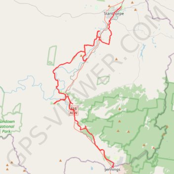
Wallangara - Stanthorpe
#MTB
- Distance: 70.9 Km
- Elevation gain: 798 m
- Maximum elevation: 880 m
- Elevation loss: 842 m
- Minimum elevation: 687 m
Interactive trail map
Make a donation
Gear up for your next adventure:
As an Amazon Associate, this site earns from qualifying purchases at no extra cost to you.
Trail profile
- Distance: 70.9 Km
- Elevation gain: 798 m
- Maximum elevation: 880 m
- Elevation loss: 842 m
- Minimum elevation: 687 m
Make a donation
Gear up for your next adventure:
As an Amazon Associate, this site earns from qualifying purchases at no extra cost to you.
About this trail
Name: Wallangara - Stanthorpe trail, distance, elevation, map, profile, GPS track
Coordinates: -28.92484 151.81302 -28.64454 151.94776
Topography: New South Wales topographic map, elevation, terrain
Make a donation
Gear up for your next adventure:
As an Amazon Associate, this site earns from qualifying purchases at no extra cost to you.
Other hiking, mountain biking, running and outdoor activity trails
Click on a trail to view its statistics, map and profile.
Make a donation
Gear up for your next adventure:
As an Amazon Associate, this site earns from qualifying purchases at no extra cost to you.
Wallangara - Stanthorpe
Australia > Queensland > Wallangarra
#Bike
Distance: 55.8 Km • Elevation gain: 635 m • Maximum elevation: 880 m
Stanthorpe - Wallangara
Australia > Queensland > Stanthorpe
#Bike
Distance: 48.6 Km • Elevation gain: 676 m • Maximum elevation: 1,096 m