Import a GPX file

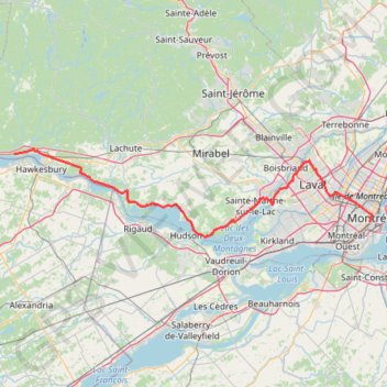
Grenville-sur-la-Rouge - Montréal

Ottawa River. #Bike #Montréal

  • Distance: 125.2 Km
  • Elevation gain: 531 m
  • Maximum elevation: 92 m
  • Elevation loss: 547 m
  • Minimum elevation: 19 m

Interactive trail map

Trail profile

  • Distance: 125.2 Km
  • Elevation gain: 531 m
  • Maximum elevation: 92 m
  • Elevation loss: 547 m
  • Minimum elevation: 19 m

About this trail

Other hiking, mountain biking, running and outdoor activity trails

Click on a trail to view its statistics, map and profile.

Québec - Montréal - Saint-Laurent River - Lake Ontario - Niagara Falls

Canada > Quebec > Urban agglomeration of Québec > Quebec

#Bike #Ontario

Distance: 1,078.4 Km • Elevation gain: 4,804 m • Maximum elevation: 209 m

Wood Key Trail

Canada > Quebec > Vaudreuil-Soulanges > Rigaud

#Hiking #Running #SnowShoes

Distance: 6.0 Km • Elevation gain: 152 m • Maximum elevation: 161 m

Pierreville - Leclercville

Canada > Quebec > Urban agglomeration of Montreal > Montreal

#Bike #Pierreville #Leclercville #Atlantic

Distance: 120.8 Km • Elevation gain: 324 m • Maximum elevation: 36 m

Salaberry-de-Valleyfield - Montréal

Canada > Quebec > Beauharnois-Salaberry > Salaberry-de-Valleyfield

#Bike

Distance: 89.9 Km • Elevation gain: 363 m • Maximum elevation: 70 m

Montréal - New York

Canada > Quebec > Urban agglomeration of Montreal > Montreal

#Bike #Montréal #NewYork

Distance: 637.6 Km • Elevation gain: 4,860 m • Maximum elevation: 301 m

East Hawkesbury - Montréal

Canada > Ontario > Prescott and Russell Counties > East Hawkesbury

#Bike #EastHawkesbury #Montréal

Distance: 91.4 Km • Elevation gain: 393 m • Maximum elevation: 91 m

Montréal - Lanoraie

Canada > Quebec > Urban agglomeration of Montreal > Montreal

Saint Lawrence River. #Bike #Montréal #Lanoraie #SaintLawrence

Distance: 70.1 Km • Elevation gain: 181 m • Maximum elevation: 52 m

Ottawa - East Hawkesbury

Canada > Ontario > (Old) Ottawa

#Bike #Ottawa

Distance: 110.2 Km • Elevation gain: 221 m • Maximum elevation: 86 m

Montréal - Berthierville

Canada > Quebec > Urban agglomeration of Montreal > Montreal

#Bike

Distance: 71.1 Km • Elevation gain: 133 m • Maximum elevation: 41 m

Lancaster - Montréal

Canada > Ontario > Stormont, Dundas and Glengarry Counties > South Glengarry > South Lancaster

#Bike #Lancaster #Montréal

Distance: 96.6 Km • Elevation gain: 267 m • Maximum elevation: 52 m

Oka - Montréal

Canada > Quebec > Deux-Montagnes (MRC) > Oka

#Bike #Montréal

Distance: 65.3 Km • Elevation gain: 268 m • Maximum elevation: 51 m

Montréal - Westmount

Canada > Quebec > Urban agglomeration of Montreal > Montreal

#Bike #Montréal

Distance: 13.7 Km • Elevation gain: 33 m • Maximum elevation: 60 m

Gear up for your next adventure:

🧺Waterproof Dry Sacks - Organize your pack and keep electronics safe from rain and river crossings
🧥Packable Rain Jackets - Breathable waterproof layers for unpredictable mountain weather
🆘Personal Locator Beacons (PLB) - Satellite emergency beacons for life-saving help in areas with no mobile coverage
🧳Outdoor Travel Organizers - Gear organization accessories
🧥Thermal Emergency Blankets - Compact Mylar blankets to prevent hypothermia if stranded overnight

As an Amazon Associate, this site earns from qualifying purchases at no extra cost to you.