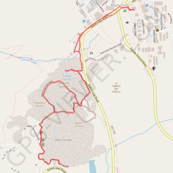
Mammoth Hot Springs Loop
Starting near the Albright Visitor Center in Yellowstone National Park, this loop follows Grand Loop Road toward Palette Spring, where steaming runoff, warm mineral colors and open views introduce the Mammoth Hot Springs landscape.
The route then crosses the Mammoth Terraces through Jupiter Terrace, Mound Terrace, Cleopatra Terrace and Main Terrace, revealing pale travertine shelves, sculpted limestone steps and shifting thermal activity across the hillside.
After continuing toward New Blue Spring, Cupid Spring, Dryad Spring and Canary Spring, the walk returns toward the Mammoth area and makes a final detour to Minerva Terrace before finishing back near the Albright Visitor Center.
#Hiking #Loop #Nature #Mountain #Volcano #Yellowstone #Thermal #Springs
- Distance: 4.5 Km
- Elevation gain: 131 m
- Maximum elevation: 2,009 m
- Elevation loss: 131 m
- Minimum elevation: 1,903 m
- Moving time: 2 h 54 m
- Moving speed: 1.5 Km/h
- Maximum speed: 4.2 Km/h
- Total time: 5 h 24 m
- Global speed: 0.8 Km/h
Interactive trail map
Trail profile
- Distance: 4.5 Km
- Elevation gain: 131 m
- Maximum elevation: 2,009 m
- Elevation loss: 131 m
- Minimum elevation: 1,903 m
- Moving time: 2 h 54 m
- Moving speed: 1.5 Km/h
- Maximum speed: 4.2 Km/h
- Total time: 5 h 24 m
- Global speed: 0.8 Km/h
About this trail
Name: Mammoth Hot Springs Loop trail, distance, elevation, map, profile, GPS track
Start: Mammoth Hotel Avenue, Cabins, Mammoth, Park County, Wyoming, United States (44.97601 -110.70133)
End: Grand Loop Road, Mammoth, Park County, Wyoming, United States (44.97602 -110.70138)
Coordinates: 44.96678 -110.70771 44.97654 -110.69947