Make a donation
Gear up for your next adventure:
As an Amazon Associate, this site earns from qualifying purchases at no extra cost to you.
Haliburton Forest
#Hiking #Loop #Haliburton
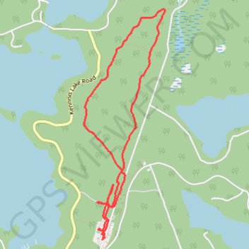
- Distance: 6.7 Km
- Elevation gain: 59 m
- Maximum elevation: 417 m
- Elevation loss: 59 m
- Minimum elevation: 389 m
Interactive trail map
Make a donation
Gear up for your next adventure:
As an Amazon Associate, this site earns from qualifying purchases at no extra cost to you.
Trail profile
- Distance: 6.7 Km
- Elevation gain: 59 m
- Maximum elevation: 417 m
- Elevation loss: 59 m
- Minimum elevation: 389 m
Make a donation
Gear up for your next adventure:
As an Amazon Associate, this site earns from qualifying purchases at no extra cost to you.
About this trail
Name: Haliburton Forest trail, distance, elevation, map, profile, GPS track
Start: North Road, Dysart et al, Haliburton County, Central Ontario, Ontario, Canada (45.22271 -78.59163)
End: North Road, Dysart et al, Haliburton County, Central Ontario, Ontario, Canada (45.22273 -78.59153)
Coordinates: 45.22271 -78.59393 45.24347 -78.58364
Make a donation
Gear up for your next adventure:
As an Amazon Associate, this site earns from qualifying purchases at no extra cost to you.
Other hiking, mountain biking, running and outdoor activity trails
Click on a trail to view its statistics, map and profile.