Tallulah Gorge Overlooks Loop via North and South Rim Trails in Tallulah Gorge State Park
The Tallulah Gorge Overlooks Loop offers an immersive experience in Georgia’s stunning Tallulah Gorge State Park. This loop provides sweeping views of the gorge, where hikers can catch glimpses of cascading waterfalls, including the multi-tiered L'Eau d'Or Falls, as well as Hurricane Falls, which is visible from a suspension bridge swaying high above the canyon floor. Along the way, visitors also encounter lush tree cover and rugged cliffside views, making it a rewarding hike with ample opportunities for photography and reflection. #Hiking #Loop #Gorge #River #Waterfall #Forest #Nature #Overlook
- Distance: 2.7 Km
- Elevation gain: 162 m
- Maximum elevation: 476 m
- Elevation loss: 157 m
- Minimum elevation: 385 m
- Moving time: 53 m 13 s
- Moving speed: 3.1 Km/h
- Maximum speed: 9.4 Km/h
- Total time: 1 h 18 m
- Global speed: 2.1 Km/h
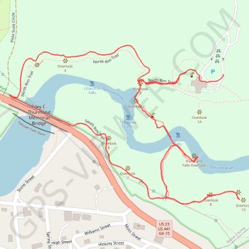
Interactive trail map
Trail profile
- Distance: 2.7 Km
- Elevation gain: 162 m
- Maximum elevation: 476 m
- Elevation loss: 157 m
- Minimum elevation: 385 m
- Moving time: 53 m 13 s
- Moving speed: 3.1 Km/h
- Maximum speed: 9.4 Km/h
- Total time: 1 h 18 m
- Global speed: 2.1 Km/h
About this trail
Name: Tallulah Gorge Overlooks Loop via North and South Rim Trails in Tallulah Gorge State Park trail, distance, elevation, map, profile, GPS track
Start: North Rim Trail, Tallulah Falls, Rabun County, Georgia, 30573, United States (34.74013 -83.39093)
End: North Rim Trail, Tallulah Falls, Rabun County, Georgia, 30573, United States (34.74007 -83.38981)
Coordinates: 34.73685 -83.39629 34.74079 -83.38932
Other hiking, mountain biking, running and outdoor activity trails
Click on a trail to view its statistics, map and profile.
Tallulah Gorge Overlooks Loop via South and North Rim Trails
United States > Georgia > Rabun County > Tallulah Falls
The Tallulah Gorge Overlooks Loop offers hikers a captivating journey through one of Georgia's most scenic state parks. Along the route, you'll encounter several breathtaking overlooks, including views of Tempesta Falls, Hurricane Falls, L'Eau d'Or Falls, and the expansive vistas of the gorge's steep walls.…
Distance: 3.6 Km • Elevation gain: 231 m • Maximum elevation: 478 m