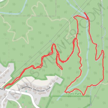
Northwest Firelane 15 Road
- Distance: 6.5 Km
- Elevation gain: 231 m
- Maximum elevation: 315 m
- Elevation loss: 231 m
- Minimum elevation: 204 m
- Moving time: 1 h 50 m
- Moving speed: 3.5 Km/h
- Maximum speed: 11.2 Km/h
- Total time: 2 h 34 m
- Global speed: 2.5 Km/h
Interactive trail map
Trail profile
- Distance: 6.5 Km
- Elevation gain: 231 m
- Maximum elevation: 315 m
- Elevation loss: 231 m
- Minimum elevation: 204 m
- Moving time: 1 h 50 m
- Moving speed: 3.5 Km/h
- Maximum speed: 11.2 Km/h
- Total time: 2 h 34 m
- Global speed: 2.5 Km/h
About this trail
Name: Northwest Firelane 15 Road trail, distance, elevation, map, profile, GPS track
Coordinates: 45.59555 -122.82368 45.60412 -122.80892
Other hiking, mountain biking, running and outdoor activity trails
Click on a trail to view its statistics, map and profile.
Ben Howard (24622956)
United States > Oregon > Multnomah County > Portland
Ben Howard (24622956)
Distance: 363.4 Km • Elevation gain: 11,851 m • Maximum elevation: 1,007 m