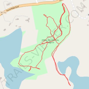
Henry Morgenthau Preserve trails
- Distance: 3.2 Km
- Elevation gain: 50 m
- Maximum elevation: 170 m
- Elevation loss: 50 m
- Minimum elevation: 145 m
- Moving time: 44 m 3 s
- Moving speed: 4.3 Km/h
- Maximum speed: 9.0 Km/h
- Total time: 52 m 19 s
- Global speed: 3.7 Km/h
Interactive trail map
Trail profile
- Distance: 3.2 Km
- Elevation gain: 50 m
- Maximum elevation: 170 m
- Elevation loss: 50 m
- Minimum elevation: 145 m
- Moving time: 44 m 3 s
- Moving speed: 4.3 Km/h
- Maximum speed: 9.0 Km/h
- Total time: 52 m 19 s
- Global speed: 3.7 Km/h
About this trail
Name: Henry Morgenthau Preserve trails trail, distance, elevation, map, profile, GPS track
Coordinates: 41.19648 -73.59148 41.20134 -73.58740
Other hiking, mountain biking, running and outdoor activity trails
Click on a trail to view its statistics, map and profile.