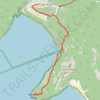
Norman Point
- Distance: 5.4 Km
- Elevation gain: 172 m
- Maximum elevation: 69 m
- Elevation loss: 175 m
- Minimum elevation: 6 m
- Moving time: 1 h 3 m
- Moving speed: 5.1 Km/h
- Maximum speed: 14.7 Km/h
- Total time: 1 h 26 m
- Global speed: 3.7 Km/h
Interactive trail map
Trail profile
- Distance: 5.4 Km
- Elevation gain: 172 m
- Maximum elevation: 69 m
- Elevation loss: 175 m
- Minimum elevation: 6 m
- Moving time: 1 h 3 m
- Moving speed: 5.1 Km/h
- Maximum speed: 14.7 Km/h
- Total time: 1 h 26 m
- Global speed: 3.7 Km/h
About this trail
Name: Norman Point trail, distance, elevation, map, profile, GPS track
Coordinates: -39.05230 146.31742 -39.03012 146.32871
Topography: Victoria topographic map, elevation, terrain
Other hiking, mountain biking, running and outdoor activity trails
Click on a trail to view its statistics, map and profile.
Wilsons Promontory Circuit
Australia > Victoria > Tidal River
Wilsons Promontory Marine National Park. #Hiking #Loop #WilsonsPromontory
Distance: 72.6 Km • Elevation gain: 3,239 m • Maximum elevation: 539 m
2023 Prom 100 km Run
Australia > Victoria > Tidal River
Distance: 101.4 Km • Elevation gain: 3,949 m • Maximum elevation: 307 m