Thank you for supporting this site ❤️
Make a donation
Make a donation
Gear up for your next adventure:
As an Amazon Associate, this site earns from qualifying purchases at no extra cost to you.
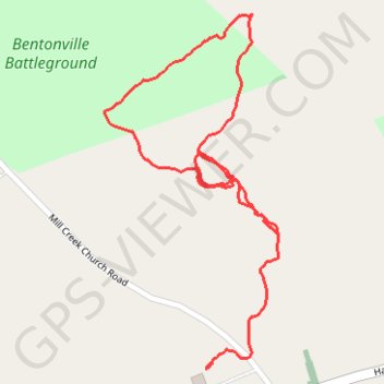
Bentonville Battleground
- Distance: 2.0 Km
- Elevation gain: 10 m
- Maximum elevation: 65 m
- Elevation loss: 12 m
- Minimum elevation: 58 m
- Moving time: 27 m 41 s
- Moving speed: 4.2 Km/h
- Maximum speed: 14.1 Km/h
- Total time: 31 m 52 s
- Global speed: 3.7 Km/h
Interactive trail map
Thank you for supporting this site ❤️
Make a donation
Make a donation
Gear up for your next adventure:
📣High-Decibel Survival Whistles - Signaling tool for rescue that carries much further than a human voice
As an Amazon Associate, this site earns from qualifying purchases at no extra cost to you.
Trail profile
- Distance: 2.0 Km
- Elevation gain: 10 m
- Maximum elevation: 65 m
- Elevation loss: 12 m
- Minimum elevation: 58 m
- Moving time: 27 m 41 s
- Moving speed: 4.2 Km/h
- Maximum speed: 14.1 Km/h
- Total time: 31 m 52 s
- Global speed: 3.7 Km/h
Thank you for supporting this site ❤️
Make a donation
Make a donation
Gear up for your next adventure:
🧭Military Style Lensatic Compass - Durable sighting compasses for advanced land navigation and surveying
As an Amazon Associate, this site earns from qualifying purchases at no extra cost to you.
About this trail
Name: Bentonville Battleground trail, distance, elevation, map, profile, GPS track
Coordinates: 35.30242 -78.32431 35.30833 -78.32077
Thank you for supporting this site ❤️
Make a donation
Make a donation
Gear up for your next adventure:
As an Amazon Associate, this site earns from qualifying purchases at no extra cost to you.