
Walk at Rock House Reservation, on Pond Trail and western Outer Loop to Fire Road
- Distance: 2.4 Km
- Elevation gain: 51 m
- Maximum elevation: 269 m
- Elevation loss: 52 m
- Minimum elevation: 236 m
- Moving time: 1 h 17 s
- Moving speed: 2.4 Km/h
- Maximum speed: 5.5 Km/h
- Total time: 1 h 14 m
- Global speed: 2.0 Km/h
Interactive trail map
Trail profile
- Distance: 2.4 Km
- Elevation gain: 51 m
- Maximum elevation: 269 m
- Elevation loss: 52 m
- Minimum elevation: 236 m
- Moving time: 1 h 17 s
- Moving speed: 2.4 Km/h
- Maximum speed: 5.5 Km/h
- Total time: 1 h 14 m
- Global speed: 2.0 Km/h
About this trail
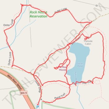
Name: Walk at Rock House Reservation, on Pond Trail and western Outer Loop to Fire Road trail, distance, elevation, map, profile, GPS track
Coordinates: 42.26813 -72.20012 42.27164 -72.19538
Other hiking, mountain biking, running and outdoor activity trails
Click on a trail to view its statistics, map and profile.

Rock House Reservation via eastern Outer Loop, Fullan Trail, Summit Loop & Fire Road
United States > Massachusetts > Worcester County > West Brookfield > Marks Garrison
Rock House Reservation, West Brookfield, Massachusetts
Distance: 3.5 Km • Elevation gain: 89 m • Maximum elevation: 311 m