Mount Dickerman via Dickerman Mountain Trail in Mount Baker-Snoqualmie National Forest
The Dickerman Mountain Trail is a challenging but rewarding route in the Mount Baker-Snoqualmie National Forest. The hike offers a steady ascent through dense forests, eventually transitioning to alpine meadows and rocky ridgelines. From the summit, hikers are treated to breathtaking views, including the expansive panoramas of Mount Baker, Glacier Peak, and Sloan Peak, with glimpses of other major Cascades mountains. While the trail can be physically demanding, especially with steep, switchback sections, the final ascent rewards with wide-ranging vistas that make the effort worthwhile. #Hiking #Mountain #Forest #Nature
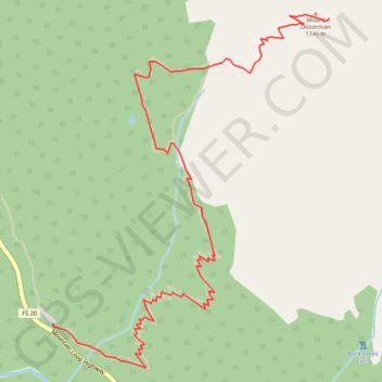
- Distance: 5.6 Km
- Elevation gain: 1,178 m
- Maximum elevation: 1,723 m
- Elevation loss: 55 m
- Minimum elevation: 597 m
Interactive trail map
Trail profile
- Distance: 5.6 Km
- Elevation gain: 1,178 m
- Maximum elevation: 1,723 m
- Elevation loss: 55 m
- Minimum elevation: 597 m
About this trail
Name: Mount Dickerman via Dickerman Mountain Trail in Mount Baker-Snoqualmie National Forest trail, distance, elevation, map, profile, GPS track
Start: Mountain Loop Highway, Snohomish County, Washington, United States (48.05380 -121.49024)
End: Dickerman Mountain Trail, Snohomish County, Washington, United States (48.06866 -121.47012)
Coordinates: 48.05165 -121.49024 48.06886 -121.47012
Other hiking, mountain biking, running and outdoor activity trails
Click on a trail to view its statistics, map and profile.
Mount Dickerman via Dickerman Mountain Trail
United States > Washington > Snohomish County
Distance: 14.5 Km • Elevation gain: 1,213 m • Maximum elevation: 1,725 m
Northern part of the Pacific Crest Trail (PCT)
United States > Oregon > Klamath County
Hike on the Pacific Crest National Scenic Trail from Crater Lake to Canada Border through Oregon and Washington along the Sierra Nevada and Cascade mountain ranges. #Hiking #Mountain #SierraNevada #Cascade #Nature #Forest #Park #PCT
Distance: 1,198.3 Km • Elevation gain: 44,308 m • Maximum elevation: 2,307 m