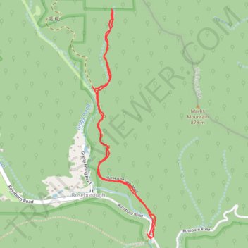
Trail off Old House Gap Road
- Distance: 4.8 Km
- Elevation gain: 223 m
- Maximum elevation: 808 m
- Elevation loss: 228 m
- Minimum elevation: 651 m
- Moving time: 54 m 33 s
- Moving speed: 5.2 Km/h
- Maximum speed: 12.1 Km/h
- Total time: 54 m 33 s
- Global speed: 5.2 Km/h
Interactive trail map
Trail profile
- Distance: 4.8 Km
- Elevation gain: 223 m
- Maximum elevation: 808 m
- Elevation loss: 228 m
- Minimum elevation: 651 m
- Moving time: 54 m 33 s
- Moving speed: 5.2 Km/h
- Maximum speed: 12.1 Km/h
- Total time: 54 m 33 s
- Global speed: 5.2 Km/h
About this trail
Name: Trail off Old House Gap Road trail, distance, elevation, map, profile, GPS track
Start: Roseboro Road, Roseborough, Avery County, North Carolina, 28616, United States (36.03201 -81.80373)
End: Roseboro Road, Roseborough, Avery County, North Carolina, 28616, United States (36.03167 -81.80342)
Coordinates: 36.03167 -81.80860 36.04817 -81.80301