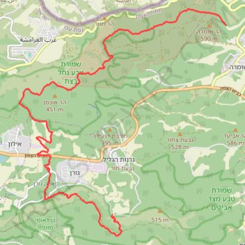
Thank you for supporting this site ❤️
Make a donation
Make a donation
Gear up for your next adventure:
As an Amazon Associate, this site earns from qualifying purchases at no extra cost to you.
בצת כזיב
- Distance: 18.2 Km
- Elevation gain: 495 m
- Maximum elevation: 478 m
- Elevation loss: 545 m
- Minimum elevation: 211 m
- Moving time: 5 h 37 m
- Moving speed: 3.2 Km/h
- Maximum speed: 5.6 Km/h
- Total time: 10 h 7 m
- Global speed: 1.8 Km/h
Interactive trail map
Thank you for supporting this site ❤️
Make a donation
Make a donation
Gear up for your next adventure:
As an Amazon Associate, this site earns from qualifying purchases at no extra cost to you.
Trail profile
- Distance: 18.2 Km
- Elevation gain: 495 m
- Maximum elevation: 478 m
- Elevation loss: 545 m
- Minimum elevation: 211 m
- Moving time: 5 h 37 m
- Moving speed: 3.2 Km/h
- Maximum speed: 5.6 Km/h
- Total time: 10 h 7 m
- Global speed: 1.8 Km/h
Thank you for supporting this site ❤️
Make a donation
Make a donation
Gear up for your next adventure:
As an Amazon Associate, this site earns from qualifying purchases at no extra cost to you.
About this trail
Name: בצת כזיב trail, distance, elevation, map, profile, GPS track
End: Maale Yosef Regional Council, Acre Subdistrict, North District, 2104302, Israel (33.04610 35.24780)
Coordinates: 33.04111 35.22093 33.09582 35.28054
Thank you for supporting this site ❤️
Make a donation
Make a donation
Gear up for your next adventure:
📣High-Decibel Survival Whistles - Signaling tool for rescue that carries much further than a human voice
As an Amazon Associate, this site earns from qualifying purchases at no extra cost to you.