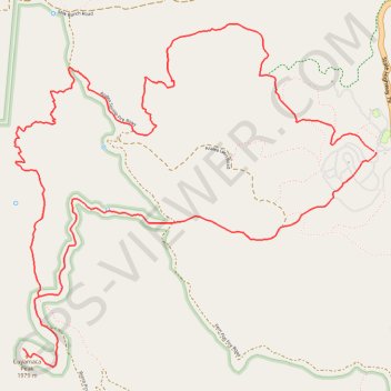
Cuyamaca Peak Loop
Loop hike from Paso Picacho Campground to Cuyamaca Peak via Azalea Trail, Conejos Trail and Lookout Road in the Cuyamaca Mountain State Wilderness. #Hiking #Loop #Mountain #Nature #Forest #Wilderness
- Distance: 11.8 Km
- Elevation gain: 571 m
- Maximum elevation: 1,970 m
- Elevation loss: 570 m
- Minimum elevation: 1,471 m
Interactive trail map
Trail profile
- Distance: 11.8 Km
- Elevation gain: 571 m
- Maximum elevation: 1,970 m
- Elevation loss: 570 m
- Minimum elevation: 1,471 m
About this trail
Name: Cuyamaca Peak Loop trail, distance, elevation, map, profile, GPS track
Start: Azalea Glen Loop Trail, San Diego County, California, United States (32.95938 -116.58064)
End: Azalea Glen Loop Trail, San Diego County, California, United States (32.95929 -116.58052)
Coordinates: 32.94596 -116.60730 32.96732 -116.58044