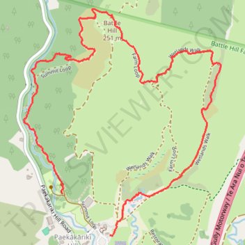
Battle Hill long loop walk
- Distance: 4.4 Km
- Elevation gain: 207 m
- Maximum elevation: 242 m
- Elevation loss: 201 m
- Minimum elevation: 58 m
- Moving time: 1 h 1 m
- Moving speed: 4.3 Km/h
- Maximum speed: 16.7 Km/h
- Total time: 1 h 6 m
- Global speed: 4.0 Km/h
Interactive trail map
Trail profile
- Distance: 4.4 Km
- Elevation gain: 207 m
- Maximum elevation: 242 m
- Elevation loss: 201 m
- Minimum elevation: 58 m
- Moving time: 1 h 1 m
- Moving speed: 4.3 Km/h
- Maximum speed: 16.7 Km/h
- Total time: 1 h 6 m
- Global speed: 4.0 Km/h
About this trail
Name: Battle Hill long loop walk trail, distance, elevation, map, profile, GPS track
Start: Paekakariki Hill, Porirua, Porirua City, Wellington, 5381, New Zealand (-41.05969 174.93872)
Coordinates: -41.05971 174.93287 -41.04807 174.94630
Other hiking, mountain biking, running and outdoor activity trails
Click on a trail to view its statistics, map and profile.
Battle Hill short loop walk
New Zealand > Wellington > Porirua City > Porirua > Paekakariki Hill
Distance: 4.0 Km • Elevation gain: 216 m • Maximum elevation: 242 m