Thank you for supporting this site ❤️
Make a donation
Make a donation
Gear up for your next adventure:
As an Amazon Associate, this site earns from qualifying purchases at no extra cost to you.
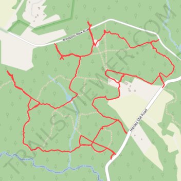
Patuxent River State Park - Annapolis Rock Parking Area
- Distance: 10.6 Km
- Elevation gain: 153 m
- Maximum elevation: 177 m
- Elevation loss: 152 m
- Minimum elevation: 138 m
- Moving time: 1 h 52 m
- Moving speed: 5.7 Km/h
- Maximum speed: 13.0 Km/h
- Total time: 1 h 59 m
- Global speed: 5.3 Km/h
Interactive trail map
Thank you for supporting this site ❤️
Make a donation
Make a donation
Gear up for your next adventure:
As an Amazon Associate, this site earns from qualifying purchases at no extra cost to you.
Trail profile
- Distance: 10.6 Km
- Elevation gain: 153 m
- Maximum elevation: 177 m
- Elevation loss: 152 m
- Minimum elevation: 138 m
- Moving time: 1 h 52 m
- Moving speed: 5.7 Km/h
- Maximum speed: 13.0 Km/h
- Total time: 1 h 59 m
- Global speed: 5.3 Km/h
Thank you for supporting this site ❤️
Make a donation
Make a donation
Gear up for your next adventure:
As an Amazon Associate, this site earns from qualifying purchases at no extra cost to you.
About this trail
Name: Patuxent River State Park - Annapolis Rock Parking Area trail, distance, elevation, map, profile, GPS track
Coordinates: 39.26818 -77.12616 39.28032 -77.10712
Thank you for supporting this site ❤️
Make a donation
Make a donation
Gear up for your next adventure:
As an Amazon Associate, this site earns from qualifying purchases at no extra cost to you.