
Disc Golf course at Ward Farm Park
- Distance: 2.6 Km
- Elevation gain: 40 m
- Maximum elevation: 37 m
- Elevation loss: 42 m
- Minimum elevation: 8 m
Interactive trail map
Trail profile
- Distance: 2.6 Km
- Elevation gain: 40 m
- Maximum elevation: 37 m
- Elevation loss: 42 m
- Minimum elevation: 8 m
About this trail
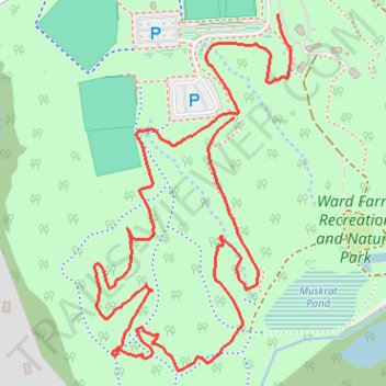
Name: Disc Golf course at Ward Farm Park trail, distance, elevation, map, profile, GPS track
Coordinates: 38.71557 -76.64874 38.72130 -76.64471
Other hiking, mountain biking, running and outdoor activity trails
Click on a trail to view its statistics, map and profile.
Ward Farm Recreation and Nature Park loop
United States > Maryland > Calvert County > Dunkirk > Woodlawn Farms
Distance: 3.8 Km • Elevation gain: 51 m • Maximum elevation: 37 m