Thank you for supporting this site ❤️
Make a donation
Make a donation
Gear up for your next adventure:
As an Amazon Associate, this site earns from qualifying purchases at no extra cost to you.
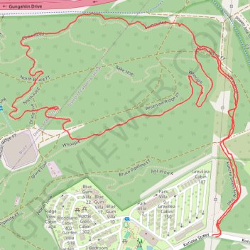
Bruce Ridge Nature Reserve
#Hiking #Loop #BruceRidge
- Distance: 3.0 Km
- Elevation gain: 53 m
- Maximum elevation: 658 m
- Elevation loss: 53 m
- Minimum elevation: 604 m
- Moving time: 1 h 5 m
- Moving speed: 2.7 Km/h
- Maximum speed: 4.7 Km/h
- Total time: 1 h 13 m
- Global speed: 2.4 Km/h
Interactive trail map
Thank you for supporting this site ❤️
Make a donation
Make a donation
Gear up for your next adventure:
As an Amazon Associate, this site earns from qualifying purchases at no extra cost to you.
Trail profile
- Distance: 3.0 Km
- Elevation gain: 53 m
- Maximum elevation: 658 m
- Elevation loss: 53 m
- Minimum elevation: 604 m
- Moving time: 1 h 5 m
- Moving speed: 2.7 Km/h
- Maximum speed: 4.7 Km/h
- Total time: 1 h 13 m
- Global speed: 2.4 Km/h
Thank you for supporting this site ❤️
Make a donation
Make a donation
Gear up for your next adventure:
As an Amazon Associate, this site earns from qualifying purchases at no extra cost to you.
About this trail
Name: Bruce Ridge Nature Reserve trail, distance, elevation, map, profile, GPS track
Coordinates: -35.25728 149.10195 -35.25231 149.10824
Topography: Canberra topographic map, elevation, terrain
Thank you for supporting this site ❤️
Make a donation
Make a donation
Gear up for your next adventure:
As an Amazon Associate, this site earns from qualifying purchases at no extra cost to you.
Other hiking, mountain biking, running and outdoor activity trails
Click on a trail to view its statistics, map and profile.
Cloudride24.FINAL
Distance: 1,028.8 Km • Elevation gain: 21,282 m • Maximum elevation: 1,754 m