Import a GPX file

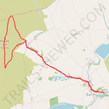
Up and down Pendle Hill

  • Distance: 6.9 Km
  • Elevation gain: 339 m
  • Maximum elevation: 558 m
  • Elevation loss: 344 m
  • Minimum elevation: 220 m
  • Moving time: 2 h 17 m
  • Moving speed: 3.0 Km/h
  • Maximum speed: 8.0 Km/h
  • Total time: 2 h 37 m
  • Global speed: 2.6 Km/h

Interactive trail map

Trail profile

  • Distance: 6.9 Km
  • Elevation gain: 339 m
  • Maximum elevation: 558 m
  • Elevation loss: 344 m
  • Minimum elevation: 220 m
  • Moving time: 2 h 17 m
  • Moving speed: 3.0 Km/h
  • Maximum speed: 8.0 Km/h
  • Total time: 2 h 37 m
  • Global speed: 2.6 Km/h

About this trail

Other hiking, mountain biking, running and outdoor activity trails

Click on a trail to view its statistics, map and profile.

Pendle Hill Loop

United Kingdom > England > Lancashire > Borough of Pendle > Barley

Loop hike from Barley via Pendle Hill, Ogden Clough, Upper Ogden Reservoir, Buttock Plantation and Lower Ogden Reservoir in the Forest of Bowland National Landscape. #Hiking #Loop #Nature #Countryside #River #Lake #Forest

Distance: 9.6 Km • Elevation gain: 346 m • Maximum elevation: 557 m

Gear up for your next adventure:

🧼Biodegradable Outdoor Soap - Clean gear and yourself without harming the local ecosystem
📡Portable Emergency Radios - Stay informed about weather warnings and bushfire alerts
🧴SPF 50+ Bulk Sunscreen - Maximum protection for long-term outdoor exposure
🛌Sleeping Mats - Insulated mats for camping comfort
📷Backpack Camera Clips - Quick access to your camera while keeping your hands free for climbing

As an Amazon Associate, this site earns from qualifying purchases at no extra cost to you.