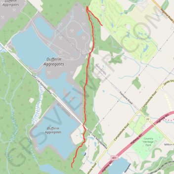
Dufferin Quarry Bridge - Bruce Trail
- Distance: 10.3 Km
- Elevation gain: 204 m
- Maximum elevation: 328 m
- Elevation loss: 204 m
- Minimum elevation: 253 m
Interactive trail map
Trail profile
- Distance: 10.3 Km
- Elevation gain: 204 m
- Maximum elevation: 328 m
- Elevation loss: 204 m
- Minimum elevation: 253 m
About this trail
Name: Dufferin Quarry Bridge - Bruce Trail trail, distance, elevation, map, profile, GPS track
Coordinates: 43.51163 -79.96049 43.54862 -79.95073
Other hiking, mountain biking, running and outdoor activity trails
Click on a trail to view its statistics, map and profile.
Rattlesnake Trail
Canada > Ontario > Halton Region
Distance: 17.3 Km • Elevation gain: 208 m • Maximum elevation: 343 m
Ontario country roads
Distance: 150.4 Km • Elevation gain: 1,137 m • Maximum elevation: 497 m